Film 3 · Texas · September 28, 2026
Why 1 in 6 Texans Live Along One Fault Line
The short version
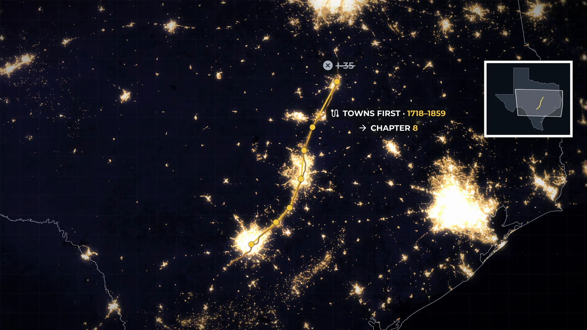
From San Antonio through Austin to Waco, seven Texas cities were founded on an almost straight line 170 miles long, and west of it the lights almost stop. It isn't Interstate 35, because all seven are older than the railroad, and it isn't a river or the coast: no river runs along the line, and the coast is more than a hundred miles away. What drew people to this one stretch of Texas lies underground, and it helps explain the floods and the droughts the cities along it face today.
Key ideas
What you need to know
The ideas the film's argument rests on, explained plainly, with the moment in the film that shows each one.
Hundreds of faults, 20 miles wide 1 of 6
Texas broke along a belt of faults
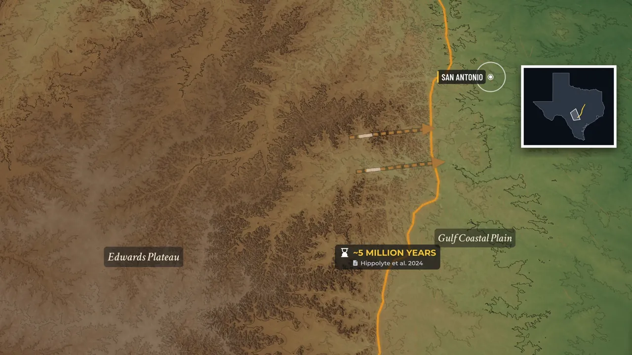
About 60 million years ago the ground here began to break. Over a few million years the crust stretched, and the land on the Gulf side slipped down along a belt of cracks running from the Rio Grande to the Red River. It is not one fault but hundreds of parallel breaks across a belt 20 miles wide, each dropping the land a little further toward the sea. Most moved about 100 feet, the largest around 600. Stacked together they add up: at New Braunfels, the rock at the surface west of town lies more than 800 feet below the lake in the middle of it. There is no record of a damaging earthquake on it.
Watch this part · 3:15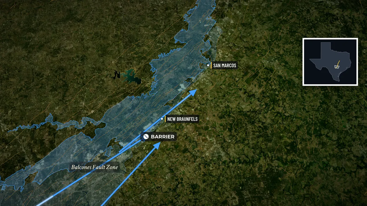
Comal, 180 million gallons a day 2 of 6
Why the springs rise along the break
Across the recharge zone, 1,250 square miles of cracked, pitted limestone lies open at the surface, so much of the rain soaks in. Rivers lose themselves in it too: in a dry year the Nueces, the Frio and the Sabinal can leave only gravel where they cross it. The water moves slowly east and downhill. Beyond the recharge band the limestone dives under younger rock that seals it in, so the water there is pushed by the weight of everything behind it. At the fault zone the broken rock will not let it past easily, so it goes up, along the line of the break. Comal Springs at New Braunfels has averaged 280 cubic feet a second since 1927.
Watch this part · 6:16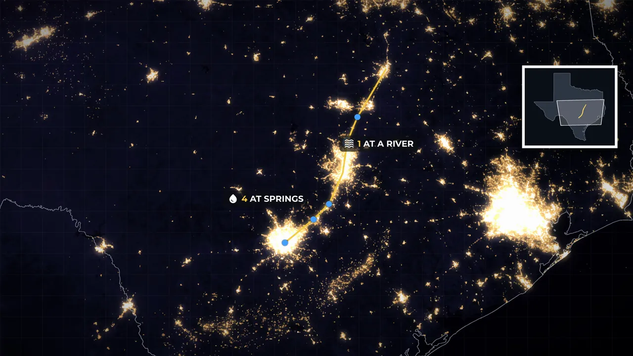
4 spring towns, 1 spring-fed river 3 of 6
Towns founded where springs last all summer
San Antonio was built on San Pedro Springs and the head of the San Antonio River, starting with a mission in 1718. In 1845 New Braunfels was laid out beside the largest spring in Texas. San Marcos grew at a spring where people have lived for more than 12,000 years, Salado was founded at its springs in 1859, and Georgetown's river is fed by more than 20 springs. None of the founders knew a fault existed. They wanted water still flowing in August. Plenty of Texas has water in April, but a spring fed by an aquifer the size of a small country can carry a town through a bad summer. That is why a spring beats a river.
Watch this part · 11:10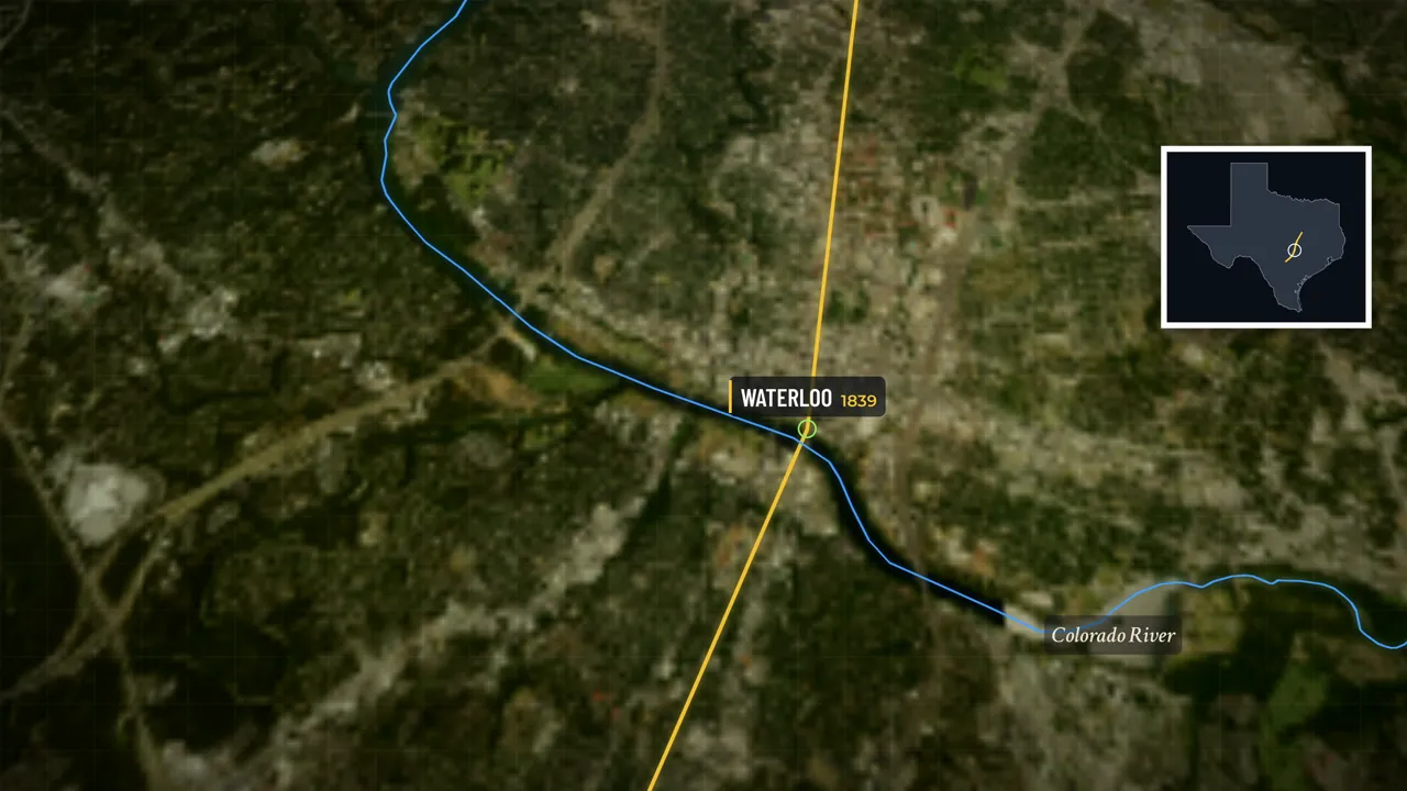
2 of 7 at river crossings 4 of 6
Austin and Waco grew at river crossings
Two of the seven were not founded on springs. In 1839 a commission picked Waterloo, a village at a crossing of the Colorado River, for the capital; the city did not own Barton Springs, two miles from the Capitol, until 1918. Waco was laid out in 1849 at a ferry crossing on the Brazos, north of where the aquifer ends. They sit on the line because the faults shape rivers too. A river cutting across the broken rock carves down into it, so at the break the banks come down to the water at a manageable grade. Upstream the Colorado runs in a gorge; downstream it spreads out and wanders. Waterloo was the last easy crossing before the hills.
Watch this part · 15:48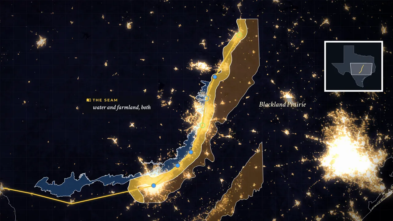
Soil water, 0.75 vs 9.39 inches 5 of 6
Rain and soil change at the line
The fault and its springs run another 150 miles west to the Rio Grande, yet that end holds about 209,000 people to the east's five and a half million. The difference is above ground. Normal rainfall rises from 14.5 inches a year at Langtry to 32 at San Antonio. On the plateau west of the line, Tarrant soil is a few inches of stony dirt on limestone that holds three quarters of an inch of water for plants. East of it, Houston Black clay on the Blackland Prairie runs more than six feet deep and holds 9.39 inches. Only along this seam do reliable water and farmable land meet, and all seven founding sites sit on its prairie side.
Watch this part · 22:15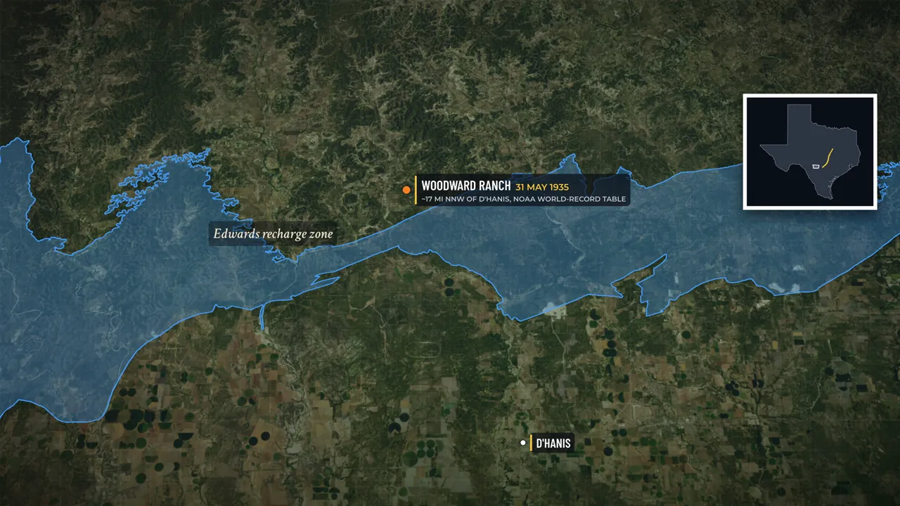
22 inches in under three hours 6 of 6
The same ground floods and runs dry
The storms come from the atmosphere; when scientists removed the escarpment from a weather model, they came about as hard. The escarpment shapes what happens after the rain lands. The limestone takes rain in through cracks, but only so fast, and the excess runs off the thin soil. Steep, narrow valleys funnel it into one channel, where the rise is measured in minutes. Streams draining the escarpment produce the greatest concentration of extreme floods in the lower 48. A ranch at D'Hanis, on the recharge zone, holds the US record of 22 inches of rain in two hours and 45 minutes. In dry years most water leaves through wells, not springs; in 1956 Comal Springs stopped for 144 days.
Watch this part · 30:31
Explore
The map from the film
Turn the film's layers on and off, switch to satellite, and click anything for what it is.
Chapters
Jump to any part
- 01Where Texas stops0:00
- 02The break3:15
- 03Where the water comes back up6:16
- 04The towns the springs made11:10
- 05The two that don't fit15:48
- 06The same fault, and nobody there18:53
- 07A few inches of soil22:15
- 08How the road got there26:09
- 09The same rock, the other way round30:31
- 10What the line is taking back35:37
Names
How locals say them
Every place name in this film was checked against local sources before it was voiced. Here is what we found.
Transcript
Read the film
The full narration, chapter by chapter. Click a time to play from there.
01Where Texas stops0:00
0:00Why do seven Texas cities form an almost straight line? From San Antonio through Austin to Waco, their founding sites trace a narrow corridor across a hundred and seventy miles. Their seven counties hold five and a half million people — more than one Texan in six. West of that corridor, the lights almost stop. The seven corridor counties hold more than eight hundred people to the square mile. The thirty-eight counties west of them hold fewer than twelve, on more than nine times as much land.
0:39The obvious answer is I thirty-five. But all seven are older than the railroad, let alone the interstate. No river runs along the line; several cross it. And the coast is over a hundred miles away. So what kept drawing people to this stretch of Texas? The answer lies beneath the ground. It helps explain both the water that brought people here — and the floods and drying springs they face today.
1:11Start with the empty half, because that is the part that tells you something is going on. Drive west out of San Antonio and Texas empties out. Eighty miles on is Uvalde, fifteen thousand people, and from there the road runs another seventy miles to Del Rio without passing a town of two thousand. Keep going and the towns come apart into names on a sign — Brackettville, Rocksprings, Langtry — until the Rio Grande stops the country altogether. Six counties sit out there. Together they cover more ground than New Jersey, and hold fewer people than Baton Rouge.
1:54Now turn around and drive back east, and something changes about twenty miles outside San Antonio: the land drops, the rivers start running clear and cold, and the cities begin. And these seven are not the only towns in the pattern. Round Rock and Belton were founded in the same few years, and they fall on the same line — Belton's courthouse square is a few hundred feet from it. Add them, and the line barely moves. Cities normally have obvious reasons — a harbour, a river mouth, a mine, a pass through mountains. No single one of them fits all seven.
2:35Rivers cross this line in a dozen places, but only two of the seven were founded at a crossing; the coast is a hundred and forty miles away; there is no mountain range. There is nothing on the surface at all that tells you where the line is, until you fly over it and see the lights stop. And it is not the Interstate, though one runs down almost the whole of it. A road goes where people already are. We will come back to that one. And the same line does one more thing to the people on it, which is the opposite of building a city. We will get to that.
02The break3:15
3:15Since the 1940s, geologists have said this part of Texas broke about twenty million years ago. When the rock inside the fault itself was finally dated, it came back closer to sixty. Not violently, and not all at once. Over a few million years the crust here stretched, and the land on the Gulf side slipped downward along a belt of cracks that runs across the state from the Rio Grande to the Red River. The Spanish called the tiers of limestone standing over the plain the balconies — balcones — and the name stuck to the whole thing.
3:53It is not one fault. It is a zone of them, hundreds of parallel breaks spread across a belt twenty miles wide, each dropping the land a little further toward the sea. No single one is dramatic — most moved a hundred feet or so, the largest around six hundred, which works out at an inch every seven hundred years. But they are stacked side by side, all leaning the same way, and they add up to something enormous: at New Braunfels the same layer of rock that sits at the surface west of town lies more than eight hundred feet below the lake in the middle of it.
4:33That is the part nobody can see, and it is the part that matters — but what does all that buried offset look like from a car window? Run a line ten kilometres long across the scarp anywhere between Uvalde and Austin, and the ground falls between two hundred and forty and three hundred and sixty feet. That is not a cliff. Drivers cross it without noticing every day of the week on the Interstate, and the only sign of it from a car window is that the billboards stop and the cedar starts. But it is a step, and it runs, unbroken, for well over a hundred miles.
5:13Further south-west it is not subtle at all. The plateau behind Del Rio stands more than fourteen hundred feet above the Rio Grande, which is why the Spanish saw balconies, and why the old maps of this country draw the same thing: a rough edge, by hand, running diagonally across the middle of Texas. And the word fault is doing work here that it should not. The youngest movement anyone has dated on it is Miocene; there is no record of a damaging earthquake on it, and the federal register of active faults does not list it. This is not a hazard. It is a plumbing fixture — and what it does to water is much of the reason five and a half million people live along it.
6:01Because when the land broke, the rock broke with it. And this particular rock, a four-hundred-to-six-hundred-foot slab of limestone laid down under a shallow sea, does something remarkable when you crack it.
03Where the water comes back up6:16
6:16Across the recharge zone, much of the rain that falls does not run off. It goes in. Twelve hundred and fifty square miles of that limestone sits exposed at the surface, cracked and pitted and drilled through by water until it works less like rock and more like a sponge with the holes joined up. Everything that sinks in moves slowly east and slightly downhill, through the dark, under pressure. And the rivers go in with it. The Nueces, the Frio, the Sabinal and Seco Creek all come down off the plateau as ordinary streams, cross onto that band of broken limestone, and lose themselves — not gradually, but stretch by stretch, until in a dry year there is a riverbed with gravel in it and no river.
7:07The water has not gone anywhere. It has gone down. Beyond the recharge band the limestone dives under younger rock, and from there on the water is sealed in, four to six hundred feet of it, held between layers that will not let it rise. That is what makes it artesian: the water in the confined part of the aquifer is under the weight of everything behind it, pushing, looking for a way up. And then it hits the faults. The broken rock along the fault zone does not let the water past easily, and water under pressure with a wall in front of it does the only thing left to do.
7:50It goes up. It comes out of the ground along the line of the break, and it comes out in volumes that are hard to believe until you stand next to one. Comal Springs at New Braunfels is the largest spring in the American Southwest. Since the gauge went in at the end of 1927 it has averaged two hundred and eighty cubic feet of water a second, which is a hundred and eighty million gallons a day — three-quarters of everything San Antonio puts through its taps, coming out of the ground on its own. San Marcos Springs, seventeen miles up the line, averages a hundred and seventy.
8:32Barton Springs in Austin, sixty-one. That water does not have to fall anywhere near where it comes out. Much of it fell on the plateau, sometimes years earlier, and travelled here underground — though in the fastest channels rain can reach a spring in days. Some of it is far older. Most wells in this aquifer draw water a few decades old, but one public-supply well under San Antonio, more than two thousand feet down, draws water that fell as rain nearly seventeen thousand years ago — and even that has some recent rain mixed into it.
9:12And the rock is so open that wells punched into it in San Antonio have produced more than sixteen thousand gallons a minute. One of them flowed twenty-four thousand. They are among the largest-yielding water wells anywhere on Earth. This is not an ordinary aquifer. It is a cave system with a city on top of it. Which is also why it is full of things that live nowhere else. More than forty species have been found in the water down there, most of them blind, most of them small: a salamander with no eyes and blood-red external gills, a catfish that has never seen daylight and is known from five wells on Earth, beetles and shrimp that live in this aquifer and nowhere else.
10:02That sounds like a footnote. It is not. Those animals are the reason a federal judge ended up deciding how much water San Antonio could take out of the ground, and that is a thread worth holding on to. Water leaves this rock two ways: up through the springs, or up through a well. In the 1890s the owner of San Antonio's waterworks found out what that means. When he let his wells run, the spring at the head of the river weakened, and at times the river nearly emptied. When he shut them off, the spring came back.
10:40There is a small building at the base of a water tower on the east side of San Antonio, and inside it is a well. It is called J-17, nobody drinks from it, and the only thing it does is report how high the water stands in the aquifer. That number now decides how much water two and a half million people are allowed to pump. We will come back to what it says. Because these springs have stopped before.
04The towns the springs made11:10
11:10Every town on this line was founded by somebody who arrived thirsty. None of them was the first. In May of 1718 a Franciscan named Olivares set up a mission beside a spring-fed creek in what is now San Antonio. The presidio, the military post that came with it, was established four days later. Thirteen years after that, fifty-six Canary Islanders arrived overland, sent by the King of Spain to put an actual town there, and they built it around the same water. The water they built on was San Pedro Springs, and the head of the San Antonio River three miles away — a pool so deep and so blue that it is called the Blue Hole.
11:59Hold on to that name. What those missions did next is the thing almost nobody knows about San Antonio. They dug ditches — gravity-fed canals, acequias, that watered every field the town ate from. One of them had to cross a creek, so in the 1740s they built it an aqueduct of cut limestone. It has been carrying water to the same fields for about two hundred and eighty years: the oldest Spanish aqueduct in the United States, and the only one still running. A hundred and twenty-seven years later, in March of 1845, a German engineer named Nicolaus Zink led the first wagons of a colonising company to the largest spring in Texas and laid out New Braunfels beside it.
12:50The society that sent them had promised farmland to families who had sold everything in Germany to get here; what it delivered was a spring, a creek and a summer of fever. The spring was real and it did not stop, and the town stayed. Seventeen miles north, San Marcos grew at a spring where people have been living for more than twelve thousand years. Spear points have come out of the mud at the bottom of that spring — twelve thousand years of people, through droughts that emptied whole regions of North America, at one pool of water that never stopped.
13:29Georgetown is the one that sits between the two kinds. It was laid out in 1848 at the forks of the San Gabriel, on land a man gave away to get a county seat put on it — a river site. But two miles up the road there are more than twenty springs coming out of the same cracked Edwards limestone, and the river the town was laid out on is fed by them. Salado was founded in 1859 where the old military road crossed Salado Creek, right at the springs — and that spot is now two hundred and sixty-four feet from the Interstate. Two hundred and sixty-four feet.
14:10The traffic going past at seventy-five miles an hour is running on a line chosen, before Texas was a state, by whoever decided where to water the horses. Four towns founded at a spring, and a fifth at a river those springs feed — all of them on the fault line, all founded by people who had no idea a fault existed. They were not looking for geology. They were looking for water that came out of the ground and kept coming out of it in August. And that word — August — is doing more work than it looks.
14:47Plenty of Texas has water in April. What decides where people stay is what is left at the end of a bad summer, and a spring fed by an aquifer the size of a small country can carry a town through one of them. That is why a spring beats a river, and why four more towns went up on that water inside fifteen years of each other. The last of the five, Salado, went up in 1859. Two years later the country was at war with itself, and within thirty years the railroads had changed what a town was for.
15:23The window in which this line was settled was narrow, and every town in it made the same decision about water. And that is the story the map seems to tell you. Water in a line, towns in a line, done. Except that two of the seven cities on this line were not founded on springs at all. And one of them is the capital.
05The two that don't fit15:48
15:48Austin does not fit. In 1839 the Republic of Texas needed a capital, and it did what governments do: it appointed a commission. The commission went looking for a site, and what it picked was a village of a few families on the north bank of the Colorado River called Waterloo, at the point where the river could be crossed. The new capital was laid out from that crossing. Barton Springs, the fourth largest spring in Texas, is two miles from the Capitol. The city did not even own it until 1918 — seventy-nine years after Austin was founded, the springs everybody now thinks of as the reason for Austin were a private ranch, then a mill site, then the water supply for a man's ice company.
16:39That matters, because Austin is the second-largest city on this line and the one that fits the story worst. If the argument were simply that springs make cities, the capital of Texas would be the exception that breaks it. Waco does not fit either. In 1849 a surveyor named Erath laid out a town at a ferry crossing on the Brazos, on the site of a Wichita village that had been there long before him and had chosen the spot for the same reason he did: it is where the river can be dealt with.
17:15There are springs at Waco. But Waco sits north of where this aquifer ends, and no source ties its water to the Balcones faults the way the sources tie San Antonio's and New Braunfels's. So why are they on the line at all, if not for the springs? Because the rivers are on the line for the same reason the springs are. A river cutting across a belt of broken, faulted rock carves down into it, and where it cuts, the banks come down to the water at a manageable grade. Upstream of the fault the Colorado runs in a gorge.
17:53Downstream it spreads out and wanders. Right at the break there is a place to get a wagon down one side and up the other, and that is what Waterloo was: not a spring, but the last easy crossing before the hills. So the honest version of this line is not seven springs. It is four springs, a fifth town on the river those springs feed, and two river crossings, and all seven on the same break in the rock: the fault decides where the water is, and the same broken ground helps explain where a river can be crossed; people did the rest.
18:32But the springs still do not explain the size of these places. A spring explains a mission, a mill and a market town. It does not explain a million people. And there is a much better test available for that — one that has been sitting a hundred miles west this whole time, where nobody went.
06The same fault, and nobody there18:53
18:53The fault does not stop at San Antonio. It keeps going, another hundred and fifty miles, all the way to the Rio Grande. And the springs keep going with it. Leona Springs at Uvalde comes out of the same aquifer. Las Moras Springs at Brackettville, further west again, pours out so reliably that the Army built a fort on it in 1852 and kept it for ninety-four years — through the Indian wars, through two world wars, until the cavalry gave up its horses. Long before the Army, it was a stop on the Comanche trail into Mexico.
19:34So the western half had everything the eastern half had. It had the fault. It had the aquifer. It had big permanent springs at known places. It had a fort, a wagon road and a stage line running past the door. So here are two halves of one fault. The same rock, the same aquifer and permanent springs of its own, the same state, settled by the same people in the same century, often by the same families moving up the same road. On one side: San Antonio, Austin, five and a half million people, a chain of cities that runs for a hundred and seventy miles.
20:17On the other: two hundred and nine thousand people, and Brackettville is seventy-nine miles from the nearest Interstate. Twenty-six to one. And it is not that nobody tried out west. Uvalde was laid out in 1855 and has been the county seat ever since. Brackettville had the fort, the stage road and a town around it for ninety years. Del Rio irrigated out of San Felipe Springs and grew wool and mohair for a century. These places were not overlooked. They were settled, at the same time, by the same kind of people, on the same water — and then they stopped growing, while the eastern end of the same fault turned into one of the fastest-growing corridors in the United States.
21:08Which kills the simple version of this story. If springs made cities, Brackettville would be San Antonio. Instead Brackettville has thirteen hundred people and is losing them, and the nearest Interstate is seventy-nine miles away. So what is different? Both halves have the same rock and the same water. One of them has five and a half million people on it and the other has almost nobody, and the fault cannot be the whole answer, because the fault runs through both. The missing difference is not in the fault or the aquifer.
21:47It is in the rain above them, and in the few inches of soil at the surface. And once you see it, the whole map stops looking like a line of cities and starts looking like what it actually is: a seam between two countries that happen to be in the same state. You can find it by doing something very simple. Stop looking at the water coming out of the ground, and start looking at the water falling on it.
07A few inches of soil22:15
22:15Rainfall in Texas goes up as you go east, and it goes up fast. At Langtry, out on the Rio Grande, the normal year brings fourteen and a half inches. At Del Rio, nineteen and a half. By San Antonio, a hundred and fifty miles east, it is thirty-two. That is thirteen more inches of rain for the same year, on the same latitude, for driving up the road. Thirteen inches is the difference between ranching and farming. It is, roughly, the difference between grass and cotton. And the wettest ground on that run is the scarp itself.
22:56Boerne gets thirty-eight inches, six more than San Antonio, twenty-three miles downhill. And the second thing changes at exactly the same line. West of it, on the plateau, the soil is called Tarrant, and there is almost none of it — a few inches of stony dirt sitting on solid limestone. Measure how much water that soil can hold for a plant, and the answer is three quarters of an inch. East of the line you are standing on Houston Black, the Blackland Prairie soil: deep, dark, heavy clay, more than six feet of it.
23:34Same measurement, same method: nine point three nine inches. Twelve times as much water held in the ground, twenty miles away. You can see what that does to the land without knowing anything about soil science. On the Edwards Plateau, three to four per cent of the land is cropland; the rest is grazed. On the Blackland Prairie, twenty-nine per cent is cropland, and after 1872 people came from the Deep South and from Europe in their thousands to farm it. So put the two maps on top of each other.
24:11Reliable water comes out of the ground along the fault line. Farmable rain and farmable soil begin at the fault line. West of it, water and nothing to grow. East of it, ground worth farming and no water you can count on. Along this road into the dry interior there is one narrow strip where you get both. Every one of these seven cities is standing on it. That strip has a name. On the map of natural regions, it is where the Edwards Plateau ends and the Blackland Prairie begins — and all seven founding sites sit on the prairie side of it, none of them more than eight miles from the edge.
24:55The two springs out west are not on it at all. They sit on thornscrub. That is the missing half of the answer, and it is worth saying slowly, because it is not the answer the map suggests. It explains why these towns took root. It does not yet explain how their line became permanent, or what this same ground does when the water comes too fast. The fault did not attract people. The fault made water reliable in a place where reliable water is rare, and it did that along the exact line where the farming country starts.
25:33A settler in 1845 was not thinking about limestone. He was thinking that here there is a spring that runs in August, and twenty miles that way there is dirt worth ploughing, and those two facts have never been true in the same place before on this journey. And one more thing came with the black soil: that clay is almost impossible to move a wagon through when it is wet. It packs, it sticks, it swallows wheels. The dry, firm, gravelly footing was up on the edge — which is why the road went there too.
08How the road got there26:09
26:09Today there is an Interstate down this entire line, and every one of the seven founding sites is within two miles of it. Salado's springs are two hundred and sixty-four feet from the pavement. It is tempting to say the highway follows the fault. It doesn't, and the way it actually happened is better. Long before anyone surveyed a highway, there was a trail through this country that ran from spring to spring, because a traveller on horseback needs water every day and knows exactly which pools have never failed.
26:45The Spanish had a name for the upper branch of it, and its route was not a mystery: it went where the water was, because on that kind of journey the water is the only thing that matters. Then in 1838 the Republic of Texas ordered a military road cut north from Austin to its frontier posts, and the troops who built it took the same line for the same reason, with the added advantage that the ground along the edge was firm. The towns grew on the road. Salado is on it. Georgetown is on it.
27:22Then the railroads arrived, and here the order matters: the railroads did not create these towns, they went to them. Austin got its first railroad at the end of December 1871, San Marcos in August 1880, and by then both places were decades old, with courthouses and newspapers and a reason for a railroad to bother. Then the paved highway followed the railroad, because that is where the freight and the customers already were. And in the 1950s the Interstate followed the highway.
27:58The federal rule for where an Interstate goes says to connect the principal metropolitan areas by routes as direct as practicable. There is nothing about geology in it. The engineers were not following a fault. They were connecting San Antonio to Austin to Waco to Dallas — cities that already stood in a line along the escarpment, some at springs and some at river crossings, because that is where the water and the fords were. So the road is not the cause. The road is the last inherited copy of decisions made by people on horseback, about water, crossings and firm ground — and no one at any step down that chain was thinking about geology at all.
28:46Which means the map you are looking at is a picture of a decision nobody made. Each generation inherited the previous one's choices and improved the surface of them: a trail became a road, a road became a railway, a railway became a highway, a highway became six lanes of concrete running past a spring that almost none of the drivers have ever heard of. The fault did not choose its line either. It broke along a seam left by a mountain range that was already gone before the first dinosaur — the old Ouachita suture, where thick continent meets the thin crust under the Gulf.
29:27Even the fault was following an older line. None of this decided which of these towns would grow huge. Austin got the capital and the university; Salado got neither, and is still a village. Geology chose the addresses, not the sizes. But every one of those later decisions was made on a line the water had already drawn. And the line is still drawing people. Since 2020 the seven counties on it have gained more than half a million — two and a half times everyone who lives in the six counties out west.
30:05Georgetown has grown by more than half. And the two counties growing fastest, Comal and Hays, are among the dozen fastest-growing in the United States. They are the two between San Antonio and Austin: the two that hold the biggest springs on the line. Which brings us back to the water. Because everything you have seen so far is the fault giving.
09The same rock, the other way round30:31
30:31Here is the other half of the bargain. Warm wet air comes off the Gulf of Mexico and moves inland across a hundred and forty miles of flat coastal plain, and the first high ground it meets is this one. When storms stall over central Texas, they can drop extraordinary amounts of rain onto the thin, rocky ground along the escarpment. It is tempting to say the escarpment makes these storms — that Gulf air runs into the high ground and is forced up into rain. Scientists tested exactly that.
31:07They rebuilt three extreme rainstorms that had centred on the escarpment in a weather model, and then took the escarpment away. The storms still came, about as hard, and the heaviest rain only slid slightly north and west. The atmosphere brings the rain. The escarpment shapes what happens after it lands. Now, the limestone up here does take water in — that is how the aquifer fills. But it takes it in through cracks, at a rate — and a rate has a ceiling. When rain falls faster than the fractures can swallow it, the excess has nowhere to wait. It runs off the thin soil on top and reaches the rivers almost at once.
31:52Which is the same soil that failed the farmer in chapter seven, doing the other thing it does. A few inches of dirt cannot absorb a downpour any more than it can hold a crop through a dry August. And the ground it sits on is steep and narrow. The hills shed the rain like a roof, into valleys that funnel it into one channel, and the rise is measured in minutes. Measured by how much water comes off each square mile of land, the streams draining this escarpment produce the greatest concentration of extreme floods anywhere in the lower forty-eight. Not the biggest floods; the most concentrated.
32:34The United States record for rain in under three hours is held by a ranch at D'Hanis, on this recharge zone: twenty-two inches in two hours and forty-five minutes. In 1921 a storm sat over Thrall, at the northern end of the line, and dropped three feet of rain in eighteen hours, which sent the Little River higher than it has ever been measured before or since. Fourteen years later the Colorado came through Austin at nearly half a million cubic feet a second — which is roughly seventeen hundred times what comes out of Comal Springs on an average day, arriving in a single afternoon.
33:17In 2015, on the Blanco at Wimberley, the river tore out the gauge measuring it at forty feet, and then went five feet higher — the biggest flood in that gauge's ninety-nine years. These are not once-a-century events happening by coincidence in one place. They are what this landscape does. In July 1987, eleven and a half inches of rain fell west of Hunt overnight, and a wall of water came down the Guadalupe. Near Comfort, a church camp was taking its campers out on buses. The water caught the last bus and a van.
33:58As they waded for dry ground, the river swept thirty-nine teenagers and four adults away. Thirty-three were rescued, most of them from the treetops. Ten teenagers drowned. And on the fourth of July 2025, on the Guadalupe above Kerrville, a band of seven to twelve inches of rain fell overnight onto the South Fork. At Hunt the river reached thirty-seven and a half feet, which is higher than the flood of 1932, the highest in that gauge's entire record. Downstream at Kerrville the water came up twenty feet in half an hour.
34:38Near Hunt, on this river, was Camp Mystic, a summer camp for girls that had been there for almost a hundred years. The water came through it in the night. Twenty-five of its campers were killed, with two of their counselors and one of the camp's directors. In all, at least a hundred and thirty-five people died, most of them along this one river. That is the same geometry that fills the springs. The cracked rock carries ordinary rain down fast, which is why it comes back out at the fault; the thin soil and the steep valleys cannot hold a cloudburst, which is why, when the rain comes fast, none of it stays where it fell.
35:23The aquifer and the flood are the same fact, measured on different days. One piece of ground, two consequences. The water that built these cities is the water that drowns them.
10What the line is taking back35:37
35:37For three centuries, people built here as if the springs were permanent. They were not. In 1956, at the end of the worst drought Texas has recorded, Comal Springs — the largest spring in the Southwest, the one New Braunfels was built on — stopped completely for a hundred and forty-four days. It is the only time in ninety-eight years of measurement that it has gone to zero. Recharge from 2020 through 2024 ran at about a quarter of the long-term average — less than it managed during the drought of record.
36:16Pumping restrictions on the aquifer have been in force continuously since 2022. Remember the two ways out. In a wet year, most of the water leaves through the springs. In a dry year it is the wells: in 2023 they took out more than twice as much as all of its springs put together. In May 2025 the well at J-17 came within eleven feet of its lowest reading, from 1956, and for the first time San Antonio's part of the aquifer went into the last of its five drought stages. This was predicted. A study of this aquifer published in 1997 said that when the historic droughts came back, major shortages would come with them.
37:07The drought it described is back. There is also a limit on what anyone can do about it. In Texas the water under your land is yours — the state supreme court ruled in 2012 that groundwater in place is private property, and that taking it away can be a taking. This aquifer is one pool, owned in thousands of separate pieces. And the authority that sets any restriction at all exists because of the blind salamander. In 1993 a federal judge, asked to protect the animals that live in Comal and San Marcos Springs, gave the Texas Legislature until the end of its session to write a law capping what could be pumped out of this aquifer. That is where the authority came from, and that is where the cap came from.
38:01And the cap is doing something. A model built to ask what this aquifer would look like without the restrictions found the wells and springs running considerably higher since 2006 than they would have otherwise — and that without them, the springs could fall below the lows of the 1950s again and again. Wet years still come, and when they do this aquifer answers fast — that is what a cave system does. The springs will rise again. The point is that a city of a million and a half people can no longer plan around whether they do.
38:39And both of the springs San Antonio began at have gone quiet — San Pedro, the water the town was founded on, and the Blue Hole at the head of the river. The Blue Hole only runs when the aquifer stands above six hundred and seventy-two feet, and it has not been that high in years. It has happened here before. A traveller who rode through in 1854 wrote that the San Antonio River never varies in height or volume. By the late 1890s, with artesian wells drilled all around its spring, the spring stopped flowing entirely, for parts of three years.
39:20By 1911 the river through downtown was running so low that a group of businessmen proposed piping what was left of it under the streets and filling in its bed to build on. Other businessmen and the city's women's clubs fought it, and the plan died. That saved riverbed is San Antonio's River Walk — and in dry spells today, the city keeps it flowing with its own recycled water. The city that exists because water came out of the ground now takes less than half its supply from that aquifer.
39:57A hundred and forty-two miles of pipe — the single biggest thing now standing in for a spring that used to come up out of the ground on its own. When Comal Springs stopped in 1956, a small fish that lived in the spring water, the fountain darter, disappeared from the river. The ones there now descend from fish brought over from San Marcos twenty years later. Today, spare populations of eight of the springs' species live in tanks at federal stations in San Marcos and Uvalde. They are kept there in case the wild ones are lost.
40:36About a million people lived along this line in 1956. Five and a half million live along it now, and it gains about a hundred thousand more every year. Why do seven Texas cities form an almost straight line? Because sixty million years ago, the ground here began to break. Where it broke, the water came back up. Four of the seven began at those springs, a fifth on a river they feed, and two where a river could be crossed — all seven on the same break. The road came last. It went where the towns already were.
41:19The same break runs a hundred and fifty miles further west with the same springs and a twenty-sixth of the people, because out there the rain and the soil never joined it. Here they did. That is the bargain this line has always offered. It does not make the rain. It shapes where the rain goes — into the springs that built these cities, off the hills and over the banks, and in the dry years, out of reach. Texas has spent three hundred years building around that. Now it is having to negotiate with it.
41:57Fly over it at night, and you can still see where the ground broke. It's where the lights stop. Thanks for joining me today. Stay tuned for what's coming next, and I'll see you next time on The Wayfaring Kind.
Your story
What did we miss?
The best things we have learned since publishing came from people who live there: family who worked the mills, the river everyone knows we forgot, the date we got wrong. Tell us yours.
Quiz
How well do you know Texas?
A few questions the film answers. Nothing is recorded; it's just for fun.
1 of 6 · Guess the number
How long is the line of seven cities, from San Antonio to Waco?
Seven. Their founding sites run about 170 miles from San Antonio through Austin to Waco, and their seven counties hold five and a half million people, more than one Texan in six.
Watch this part · 0:002 of 6 · Question
Why can't Interstate 35 explain why these cities line up?
All seven cities are older than the railroad, let alone the Interstate. A road goes where people already are.
Watch this part · 0:393 of 6 · Question
Why does water come out of the ground along the line of the break?
Water sealed in the limestone is pushed by everything behind it. The broken rock of the fault zone will not let it past easily, so it goes up, at springs like Comal.
Watch this part · 7:074 of 6 · Say it like a local
Say it like a local: New Braunfels.
new BRAWN-fulz, as Austin's KXAN puts it. We checked every place name in this film against local sources before recording it.
Watch this part · 3:535 of 6 · Tap the map
The line starts at San Pedro Springs in San Antonio. Tap where you think it ends.
Waco, at a Brazos River crossing about 170 miles up the line. Like Austin, it grew at a river crossing rather than a spring.
Watch this part · 15:486 of 6 · Question
The fault and its springs run on west, so why did that half stay nearly empty?
Rain and soil. San Antonio gets 32 inches a year, Langtry 14.5, and the plateau's few inches of soil hold three quarters of an inch of water against 9.39 in the Blackland clay.
Watch this part · 21:47Sources & credits
Where it comes from
- Map imagery and elevation: USDA NAIP and USGS 3DEP via the USGS National Map; NASA Blue Marble and Black Marble (public domain).
- Map data: US Census Bureau; USGS; EPA/USGS ecoregions; Texas Commission on Environmental Quality (recharge zone); Edwards Aquifer Authority (artesian zone); Texas Water Development Board (aquifer extent); © OpenStreetMap contributors, ODbL, https://www.openstreetmap.org/copyright
- Chart data: USGS, including the Blanco River gage at Wimberley (08171000); J-17 water levels: Edwards Aquifer Authority, via Texas Water Development Board; TWDB Report 345; San Antonio Water System; NOAA; US Census Bureau; USDA NRCS; Collins (1994); Handbook of Texas.
- Music: Epidemic Sound — Unfinished Stories (Lennon Hutton); Idyll (Infinity Ripple); Clusters (Jakob Ahlbom & Christoffer Moe Ditlevsen); In Search of Wonder (Brendon Moeller); Folded at the Corner (Instrumental Version) (Kylie Dailey); Radar Focus (Blue Saga); Furthest I've Been from Home (Rebecca Mardal); My First My Last (Tribute Version) (Instrumental Version) (Love Beans); Open Road (Lennon Hutton); Estimations (Christoffer Moe Ditlevsen); Theme of Uncertainty (William Claeson); Beyond the Western Horizon (Howard Harper-Barnes).
- Footage:
- • Video courtesy of the Earth Science and Remote Sensing Unit, NASA Johnson Space Center ('Mexico to New Brunswick', eol.jsc.nasa.gov)
- • National Archives, Ford Motor Company Collection (FC-FC-98), NAID 7418963
- • NOAA / National Weather Service Austin/San Antonio; radar loop cropped and adapted for this film; not an official National Weather Service product
- • U.S. Army Corps of Engineers, Fort Worth District / Patrick Adelmann (DVIDS 975916)
- • US Fish & Wildlife Service, National Conservation Training Center, Creative Imagery
- Images credited as their holders ask:
- • DeGolyer Library, Southern Methodist University
- • DeGolyer Library, Southern Methodist University — Mary E. Jacobson, 'Beauties of San Antonio River. A Scene Near the Springs.', ca. 1892
- • DeGolyer Library, Southern Methodist University — Moorhead, 'Fort Clark, Tex. from Top of Water Tower', ca. 1910-1918
- • Image courtesy of the Earth Science and Remote Sensing Unit, NASA Johnson Space Center (ISS064-E-15994, eol.jsc.nasa.gov)
- • NASA Earth Observatory / LANCE/EOSDIS MODIS Rapid Response Team at NASA GSFC
- • Image courtesy of the Earth Science and Remote Sensing Unit, NASA Johnson Space Center (STS062-97-143, eol.jsc.nasa.gov)
- Documents shown:
- • Fifth Circuit, Sierra Club v. Babbitt (2 July 1993), slip opinion, p. 2
- • Federal-Aid Highway Act of 1944, sec. 7, 58 Stat. 842
- • NOAA, Storm Data, July 1987, p. 14
- • Texas Legislature, General Investigating Committees report, 18 June 2026, p. 47
- • Edwards Aquifer Authority v. Day, Supreme Court of Texas, 24 February 2012, slip opinion, p. 28
- • Rep. Jack Fields, Congressional Record, 16 February 1993, p. 2806
- • Robert T. Hill and T. Wayland Vaughan, USGS Eighteenth Annual Report, Part II (1898), p. 313
- • San Antonio Light, Sept. 21, 1911, p. 6
- • O. E. Meinzer, Large Springs in the United States (USGS, 1927), p. 37
- • Frederick Law Olmsted, A Journey Through Texas (1857), p. 157
- • USFWS, Endangered Species Technical Bulletin, March 1985, p. 10
- Other images: public domain or no known restrictions — Austin History Center (Austin Public Library), Internet Archive, Library of Congress, NASA, National Archives, New Braunfels Public Library, U.S. Fish and Wildlife Service, USGS, Wikimedia Commons.
- Fonts: Montserrat, Barlow Condensed, Crimson Text and D-DIN Condensed (SIL Open Font License 1.1); Material Symbols (Google, Apache 2.0).